Navionics+ Cartography, North Regions
Sale
$124.91
$142.49
12% Off

FREE Shipping
Estimated delivery in 5-7 days
Estimated delivery in 5-7 days
FREE In-Store Pickup
Not Available
- This item is currently not available
- Delivery to Change Address
- Delivery Fee Details
This item is excluded from all discounts and promotions.
Minimum order quantity of
1
Maximum order quantity of
100
Must purchase in increments of
1

Return Policy
We believe in offering the very best value, quality, and selection. Plus, we want you to enjoy your purchase! In the event you wish to send a product back to us, you may return most unused items for a refund or exchange, minus shipping, within 90 days from the date of purchase unless noted below under exceptions and exclusions. Refunds are issued to the original form of payment.
Features
Detailed marine cartography makes Navionics+ the perfect choice for cruising, fishing, and sailing. On this small MicroSD card, you'll get the most accurate navigational data for your GPS plotter, an exclusive HD bathymetry map which is enhanced by experienced boaters, and unique local content shared by Navionics app users. Navionics cartography designers make thousands of edits every day, so you can always have the most current charts for your boating adventures. Daily updates and advanced features are included for one year. Includes more than 7,500 lakes.
Features:
• Precision and Accuracy: View the exact position of your vessel, detailed coastal features, obstructions, waterways, and depth contours so you will always know precisely where you are and where you want to go.
• Advanced Features: 3D view, high-resolution photo/chart overlay, port photos, and geo-referenced coast pilots are all part of the Navionics+ package.
• SonarChart: With high-definition 1' bathymetry nearshore and 3' - 6' contours offshore beyond 90', you will get a clear view of the underwater landscape. Add your own sonar data to the mix, and create detailed maps of your favorite routes and anchorages.
• More than Maps: To ensure the best boating experience, Navionics+ doesn't stop at maps and viewpoints. Port services information and local tides and currents are included on this card so you'll have access to all the data you need to make each voyage a success.
• Community Edits: Corrections, adjustments, and additions made by the boating community can be downloaded and added to your charts daily.
• Freshwater/Saltwater Charts: With Navionics+, you get both fresh and saltwater charts in the covered region.
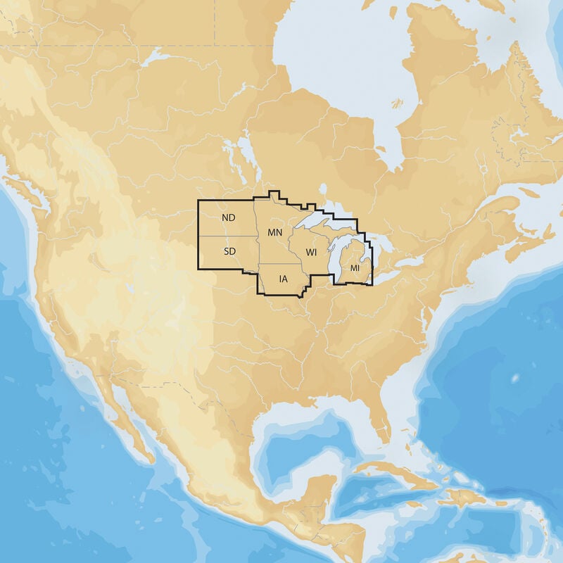
Coverage:
• Northern US: Inland
• IA, MI, MN, ND, SD, WI
Features:
• Precision and Accuracy: View the exact position of your vessel, detailed coastal features, obstructions, waterways, and depth contours so you will always know precisely where you are and where you want to go.
• Advanced Features: 3D view, high-resolution photo/chart overlay, port photos, and geo-referenced coast pilots are all part of the Navionics+ package.
• SonarChart: With high-definition 1' bathymetry nearshore and 3' - 6' contours offshore beyond 90', you will get a clear view of the underwater landscape. Add your own sonar data to the mix, and create detailed maps of your favorite routes and anchorages.
• More than Maps: To ensure the best boating experience, Navionics+ doesn't stop at maps and viewpoints. Port services information and local tides and currents are included on this card so you'll have access to all the data you need to make each voyage a success.
• Community Edits: Corrections, adjustments, and additions made by the boating community can be downloaded and added to your charts daily.
• Freshwater/Saltwater Charts: With Navionics+, you get both fresh and saltwater charts in the covered region.
Coverage:
• Northern US: Inland
• IA, MI, MN, ND, SD, WI
- Detailed cartography for cruising and fishing
- Accurate navigational data for your GPS plotter
- HD bathymetry map enhanced by experienced boaters
- Includes daily updates and features for one year
Specs
Unit Weight
0.22 lb
Brand
Navionics
MFG Part No.
0
 800-700-1366