Garmin GPSMAP 942XS Plus Touchscreen GPS/Fishfinder Combo
$1,399.99

FREE Shipping
Estimated delivery in 5-7 days
Estimated delivery in 5-7 days
FREE In-Store Pickup
Select store
- This item is currently not available
- Delivery to Change Address
- Delivery Fee Details
This item is excluded from all discounts and promotions.
Minimum order quantity of
1
Maximum order quantity of
100
Must purchase in increments of
1

Return Policy
We believe in offering the very best value, quality, and selection. Plus, we want you to enjoy your purchase! In the event you wish to send a product back to us, you may return most unused items for a refund or exchange, minus shipping, within 90 days from the date of purchase unless noted below under exceptions and exclusions. Refunds are issued to the original form of payment.
Features
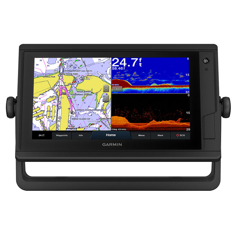
Advanced navigation. Ultimate integration. This compact 9” GPSMAP 942xsv Plus touchscreen combo features enhanced map drawing and seamlessly integrates into your Garmin marine system for full control of your connected helm. It supports 1 kW CHIRP traditional sonar, ClearVü scanning sonar and Panoptix all-seeing sonar, including Panoptix LiveScope sonar. Preloaded BlueChart g3 coastal charts and LakeVü g3 inland maps give you the best of Garmin and Navionics data and Auto Guidance technology. Share maps, user data, radar and IP cameras among multiple units using the Garmin Marine Network. NMEA 2000 and NMEA 0183 networking connect you to autopilots, digital switching, weather, media, VHF, AIS and other sensors. Plus, this unit uses ANT technology to pair with compatible Garmin devices, such as marine watches, transducers, wireless remote controls and more. It also includes built-in Garmin SailAssist features, such as laylines, race features, set and drift, wind data, and more.
Traditional & Scanning Sonars
Get built-in support for 1 kW CHIRP traditional sonar for superior target separation and ClearVü scanning sonar to see up to 1,000’ below your boat at 260 kHz (transducer sold separately).
Panoptix Sonar Support
Pair with Panoptix or Panoptix LiveScope easy-to-interpret live sonar (transducer sold separately) to see all around your boat in real time.
Preloaded Mapping
Experience unparalleled coverage and detail with preloaded BlueChart g3 coastal charts and LakeVü g3 inland maps featuring integrated Garmin and Navionics® content and Auto Guidance1 technology.
Optional BlueChart g3 Vision Charts
Upgrade to our reliable premium charts, which add even more industry leading features, such as high-resolution relief shading, to help you on each trip.
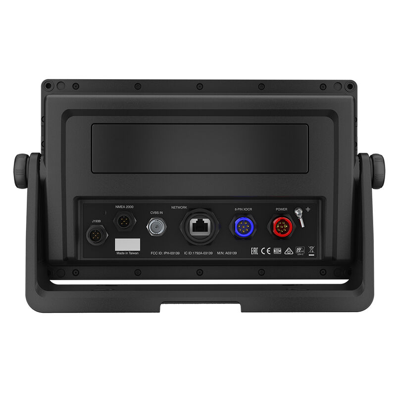
Garmin Marine Network
If you have multiple Garmin devices on your boat, you can share information — such as maps, user data, radar and IP cameras among them.
NMEA 2000 & NMEA0183 Networks
Connect to autopilots, digital switching, weather, FUSION-Link audio system, media, VHF, AIS, and more from one screen.
ActiveCaptain App
Built-in Wi-Fi connectivity pairs with the free all-in-one mobile app for access to the OneChart feature, smart notifications2, software updates, Garmin Helm, Garmin Quickdraw Community data, and more.
Integrated ANT Technology
Connect with some of your favorite devices, such as quatix marine watches, gWind Wireless 2 transducers, GNX Wind marine instruments, and wireless remote controls.
JI939 Connectivity
Now you can connect your chartplotter to different kinds of engines, including Yamaha engines.
OneHelm Feature
This exclusive feature brings together all the operations and capabilities of third-party devices, such as EmpirBus digital switching, on one screen.
In The Box
GPSMAP 942xs Plus chartplotter
Power cable
Bail mount with knobs
Flush mount kit with gasket
Protective cover
Trim piece snap covers
Documentation
Traditional & Scanning Sonars
Get built-in support for 1 kW CHIRP traditional sonar for superior target separation and ClearVü scanning sonar to see up to 1,000’ below your boat at 260 kHz (transducer sold separately).
Panoptix Sonar Support
Pair with Panoptix or Panoptix LiveScope easy-to-interpret live sonar (transducer sold separately) to see all around your boat in real time.
Preloaded Mapping
Experience unparalleled coverage and detail with preloaded BlueChart g3 coastal charts and LakeVü g3 inland maps featuring integrated Garmin and Navionics® content and Auto Guidance1 technology.
Optional BlueChart g3 Vision Charts
Upgrade to our reliable premium charts, which add even more industry leading features, such as high-resolution relief shading, to help you on each trip.
Garmin Marine Network
If you have multiple Garmin devices on your boat, you can share information — such as maps, user data, radar and IP cameras among them.
NMEA 2000 & NMEA0183 Networks
Connect to autopilots, digital switching, weather, FUSION-Link audio system, media, VHF, AIS, and more from one screen.
ActiveCaptain App
Built-in Wi-Fi connectivity pairs with the free all-in-one mobile app for access to the OneChart feature, smart notifications2, software updates, Garmin Helm, Garmin Quickdraw Community data, and more.
Integrated ANT Technology
Connect with some of your favorite devices, such as quatix marine watches, gWind Wireless 2 transducers, GNX Wind marine instruments, and wireless remote controls.
JI939 Connectivity
Now you can connect your chartplotter to different kinds of engines, including Yamaha engines.
OneHelm Feature
This exclusive feature brings together all the operations and capabilities of third-party devices, such as EmpirBus digital switching, on one screen.
In The Box
GPSMAP 942xs Plus chartplotter
Power cable
Bail mount with knobs
Flush mount kit with gasket
Protective cover
Trim piece snap covers
Documentation
- Compact touchscreen combo with enhanced map drawing
- Preloaded BlueChart g3 coastal and LaveVu g3 inland maps
- NMEA 0183 and NMEA 2000 networking capabilities
- Integrated ANT technology connects to your favorite devices
Specs
Antenna
Internal
Dimensions
10.1" x 6.4" x 2.1"
Display Resolution
1024 x 600
Display Size
9" diagonal
Display Type
SVGA
Included Cartography
BlueChart g3 Coastal / LakeVu g3 Inland Maps
Max. Depth
5000.00 ft
Model Number
GPSMAP 942XS
Network/Interface
NMEA 0183 / NMEA 2000
Waterproof
Yes
Unit Weight
5.60 lb
Brand
Garmin
MFG Part No.
80819
WARNING: Cancer and Reproductive Harm
For more information, go to www.P65Warnings.ca.gov/product.
 800-700-1366