Garmin GPSMAP 1243xsv Combo GPS/Fishfinder GN+
$3,099.99

Shipping
FREE In-Store Pickup
Select store
- Ships from vendor
- Delivery to Change Address
- Delivery Fee Details
This item is excluded from all discounts and promotions.
Minimum order quantity of
1
Maximum order quantity of
100
Must purchase in increments of
1

Return Policy
We believe in offering the very best value, quality, and selection. Plus, we want you to enjoy your purchase! In the event you wish to send a product back to us, you may return most unused items for a refund or exchange, minus shipping, within 90 days from the date of purchase unless noted below under exceptions and exclusions. Refunds are issued to the original form of payment.
Features
GPSMAP 1243xsv Combo GPS/Fishfinder GN+
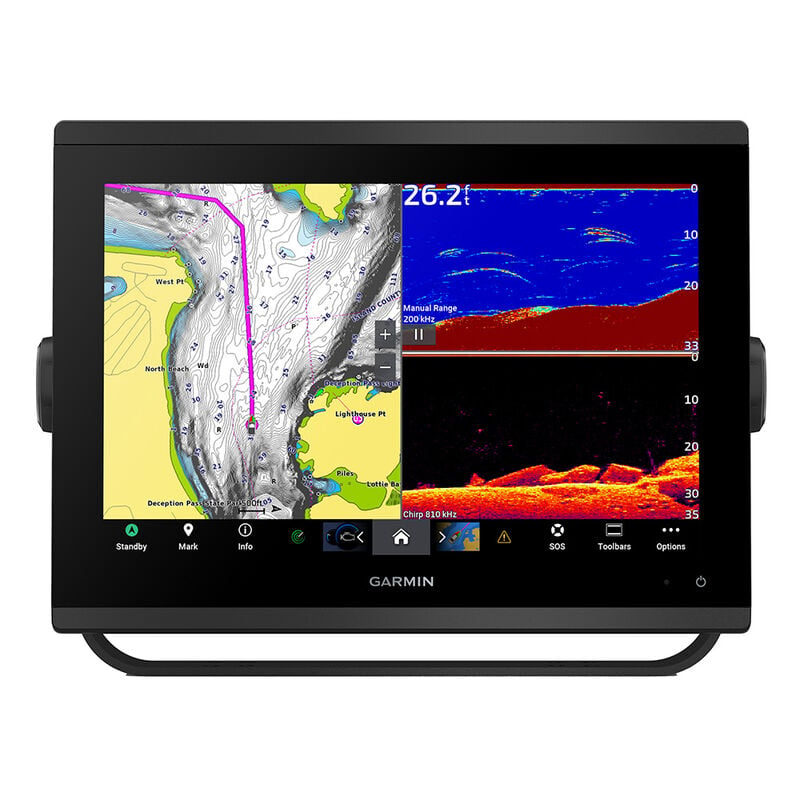
You’re an angler who wants premium features, maps, and charts for your connected helm, plus built-in sonar. This crisp 12" high-resolution chartplotter makes that wish come true.
Get a sharper view from your connected helm with the GPSMAP 1243xsv chartplotter. With its high-resolution 12” in-plane switching display, ultra-sleek design, and vivid sonar color palette, it seamlessly integrates into your Garmin marine system. GPSMAP 1243xsv also features built-in Ultra High-Definition SideVü and ClearVü scanning sonars and supports 1 kW CHIRP traditional sonar as well as fully networkable radar and live sonar devices. Preloaded Garmin Navionics+ coastal charts and inland mapping feature Auto Guidance+ technology (Auto Guidance+ is for planning purposes only and does not replace safe navigation operations) for helping you get where you need to go. Plus, there’s support for optional Garmin Navionics Vision+ premium map content. Easily build your marine system — from compatible sonar and autopilots to compatible radar, cameras, and multimedia — by using HTML 5.0, NMEA 2000 and NMEA 0183 network connectivity, J1939 for engines, and the Garmin Marine Network. Or pair your plotter with your other compatible Garmin devices, such as quatix marine smartwatches, wind transducers, wireless remote controls, and more.
Features:
- High-resolution in-plane switching touchscreen display offers improved sunlight readability and wide-angle visibility over previous-generation 12” units
- Fast and responsive, this robust GPSMAP system references 10 Hz GNSS (GPS, GLONASS, and Galileo) for accurate positioning and smooth speed as well as COG data
- Slimline display borders, edge-to-edge glass, and reduced unit footprint make for easy retrofit in a wider range of dash configurations
- Preloaded Garmin Navionics+ coastal charts and inland mapping feature Auto Guidance+ technology (Auto Guidance+ is for planning purposes only and does not replace safe navigation operations); plus, there’s support for optional Garmin Navionics Vision+ premium map content.
- J1939 engine connectivity for easy integration with engines and our exclusive OneHelm feature for connecting to your compatible third-party devices, such as EmpirBus digital switching
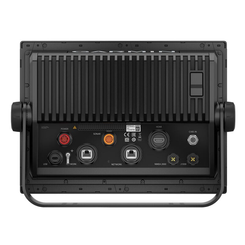
- Easily build your marine system — from compatible sonar and autopilots to compatible radar, cameras and multimedia — by using NMEA 2000 and NMEA 0183 network connectivity and the Garmin Marine Network
- Use built-in Wi-Fi networking to pair with the free ActiveCaptain smartphone app for access to the OneChart feature, smart notifications, software updates, and more.
- Integrated ANT connectivity support for use with your compatible quatix marine smartwatches, gWind Wireless 2 transducer, GNX Wind marine instrument, and wireless remote controls
- Built-in Ultra High-Definition SideVü and ClearVü scanning sonars with high-contrast vivid color palettes to help distinguish fish from structure
- Supports live sonar devices, 1 kW CHIRP traditional sonar, and more
What's In The Box?
- Chartplotter
- microSD preinstalled
- Power cable
- NMEA 2000 T-connector
- NMEA 2000 drop cable
- Bail mount with knobs
- Flush mount kit with gasket
- Protective cover Trim piece snap covers
- Documentation
- GPSMAP x3 chartplotters are preloaded with Garmin Navionics+ offshore, coastal, and inland water charts for the U.S. and Canada
 WARNING: This product can expose you to chemicals including NICKEL (METALLIC) which is known to the State of California to cause cancer. For more information go to P65Warnings.ca.gov.
- High-resolution in-plane switching touchscreen display offers improved sunlight readability and wide-angle visibility over previous-generation 12” units
- Fast and responsive, this robust GPSMAP® system references 10 Hz GNSS (GPS, GLONASS, and Galileo) for accurate positioning and smooth speed as well as COG data
- Adds a stunning appearance with the ability to install multiple displays either flat mounted edge-to-edge to create a sleek glass helm look or mounted flush
- Easily build your marine system — from compatible sonar and autopilots to compatible radar, cameras and multimedia — by using NMEA 2000® and NMEA 0183 network connectivity and the Garmin Marine Network
- Use built-in Wi-Fi® networking to pair with the free ActiveCaptain® smartphone app for access to the OneChart™ feature, smart notifications, software updates, and more.
Specs
Unit Weight
11.50 lb
Brand
Garmin
MFG Part No.
97020
WARNING: This product can expose you to CHEMICALS-C, a chemical known to the State of California to cause cancer.
For more information, go to www.P65Warnings.ca.gov/product.
 800-700-1366