Garmin BlueChart g2 Vision HD Cartography, Jacksonville - Bahamas
$449.99

Shipping
FREE In-Store Pickup
Select store
- Ships from vendor
- Delivery to Change Address
- Delivery Fee Details
This item is excluded from all discounts and promotions.
Minimum order quantity of
1
Maximum order quantity of
100
Must purchase in increments of
1

Return Policy
We believe in offering the very best value, quality, and selection. Plus, we want you to enjoy your purchase! In the event you wish to send a product back to us, you may return most unused items for a refund or exchange, minus shipping, within 90 days from the date of purchase unless noted below under exceptions and exclusions. Refunds are issued to the original form of payment.
Features
Coverage:
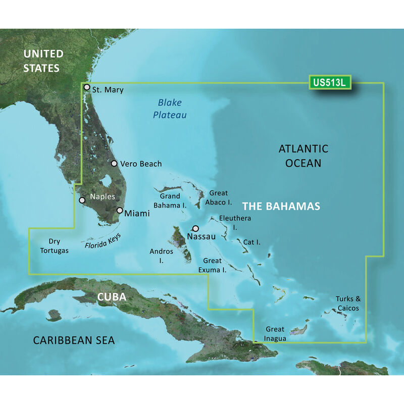
Detailed coverage of the Florida Peninsula from St. Mary's, GA through the Port of Miami to Fort Myers on the Gulf. Coverage includes the St. Johns River, Crescent Lake, Lake George, Lake Monroe, Lake Jesup, Lake Harney, Lake Okeechobee, the St. Lucie Canal, and Caloosahatchee River. Detailed coverage also includes the Florida Keys, Bahamas, and Turks and Caicos Islands. Bathymetric coverage of offshore features from Blake Canyon through Santaren Channel to the Torgtugas Terrace, including the Blake Escarpment and Great Bahama Bank.
Premium Mapping and Graphics Capabilities
• Detailed nautical charts in vector object-oriented format derived from government charts and private sources to provide port plans, depth contours, navigational aids, and tides and currents in a seamless chart presentation
• Shaded depth contours and inter-tidal zones with spot soundings
• Aerial photos of ports, marinas, bridges, and navigational landmarks and realistic "view from space", high-resolution satellite imagery
• Up to 1' HD contours provide a more accurate depiction of bottom structure for improved fishing charts and navigation in swamps, canals, marinas, and port plans
• Garmin Auto Guidance 3.0 technology is capable of providing routing guidance to virtually any accessible destination on the water
• Worldwide coverage available in regionalized cuts
Based on the standard BlueChart g2 HD features, BlueChart g2 Vision HD provides premium mapping and graphics capabilities. Plug a BlueChart g2 Vision HD card into your compatible chartplotter's microSD/SD card slot to tremendously expand its mapping capabilities. BlueChart g2 Vision HD is a premium marine cartography for use with Garmin chartplotters. It includes all the features of BlueChart g2 HD charts and adds Garmin exclusive Auto Guidance 3.0. Garmin Auto Guidance 3.0 technology quickly searches relevant charts to suggest a course according to your boat's dimensions and creates a visual path that seeks to avoid low bridges, shallow water, and other charted obstructions. With version 3.0, Auto Guidance can guide the user and in and out of more places more effectively, including entering and exiting marinas. In addition to highly detailed nautical chart data, BlueChart g2 Vision HD also adds 3D above and below the waterline, aerial photos, satellite imagery, and coastal roads, as well as points of interest.
Enter the World of Auto Guidance 3.0
By adding a BlueChart g2 Vision HD card to your compatible chartplotter, you can take advantage of patented Garmin Auto Guidance 3.0 technology. Enter the location where you want to go, and Auto Guidance 3.0 instantly searches through relevant charts to create a path specifically designed for the dimensions of your boat. Auto Guidance provides a visual path that seeks to avoid low bridges, shallow water, and other charted obstructions. But it also provides navigational solutions, such as entering and exiting marinas. When Auto Guidance 3.0 is coupled with a Garmin autopilot system, you can engage your compatible autopilot to follow the Auto Guidance route, and it will keep you on route automatically.
Enhance Your Vision
High-resolution satellite imagery enhances chart depictions for superior situational awareness so you can navigate with a clear moving-map representation of your boat's position. It's the most realistic mapping display in a chartplotter.
• High resolution imagery with navigational charts overlaid gives you a realistic view of your surroundings
• Crystal clear aerial photography shows exceptional detail of many ports, harbors, and marinas
• MarinerEye view provides a 3D representation of the surrounding area both above and below the waterline
• FishEye view provides a 3D representation of the ocean floor as seen from below the waterline
Get the Best View
BlueChart g2 Vision HD data lets you select true 3D MarinerEye view or FishEye view perspective for dynamic views both above and below the waterline. Auto Guidance 3.0 technology suggests the best routes to follow. Aerial photos of ports, harbors, marinas, waterways, and coastal roads help you see the big picture when you're on the water.
Features:
• Compatible devices must accept microSD or SD card
• Up to 1' HD fishing contours
• Seamless chart presentation
• Vector object-oriented data
• Shaded depth contours and inter-tidal zones with spot soundings
• Port plans
• Tidal stations for selected countries
• Aids to navigation with view range and coverage, including light sectors information
• Wrecks, restricted areas, anchorages, obstructions
• Tidal current graphs
• 2D or 3D map perspective view
• Marina points of interest and slipways
• Full bathymetric fishing charts providing detailed contours
• Auto Guidance 3.0 technology to suggest best passages
• Full color aerial photos of ports, marinas, bridges, and navigational landmarks
• Detailed coastal roads up to 5 miles inland (non-routable)
• Points of interest such as restaurants, lodging, entertainment, and more
• Realistic "view from space" high-resolution satellite imagery
• True 3D-view below-waterline perspective and 3D Mariner's Eye View
• Tidal current flow overlay
- Detailed nautical charts
- Auto Guidance 3.0 provides superior routing
- High resolution satellite imagery
- Choose from 2D or 3D views
Specs
Unit Weight
0.30 lb
Brand
Garmin
MFG Part No.
30408
WARNING: Cancer and Reproductive Harm
For more information, go to www.P65Warnings.ca.gov/product.
 800-700-1366