
Geonav GIS12 Integrated Multi-Function Displays with NMEA 2000
$2,849.99

Ship to Home
Delivery time calculated in checkout
Delivery time calculated in checkout
- This item is currently not available
Free Standard Shipping
This item is excluded from all discounts and promotions.
Minimum order quantity of
1
Maximum order quantity of
100
Must purchase in increments of
1

Return Policy
We believe in offering the very best value, quality, and selection. Plus, we want you to enjoy your purchase! In the event you wish to send a product back to us, you may return most unused items for a refund or exchange, minus shipping, within 90 days from the date of purchase unless noted below under exceptions and exclusions. Refunds are issued to the original form of payment.
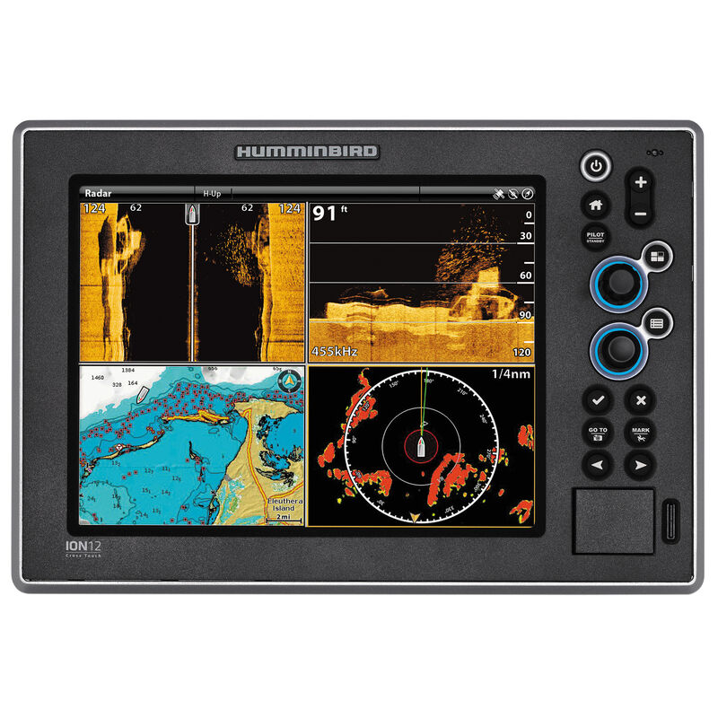
Features
The Geonav Multi-Function Display puts you in control, giving you access to invaluable information about your vessel and its surroundings.
BlueLogic User Interface
• Intuitive system
• HaloView selection
• X-Press Menu shows most-used functions
DualFuel Cartography
• Preloaded with Navionics and C-Map by Jeppesen world base maps
High-Speed Networking
• Built-in NMEA 2000
• High-Speed Ethernet
• Connect multiple Multi-Function Displays with GNS5 Network Switch (not included)
HD Ethernet Radar
• Connect an HD Ethernet Radar Scanner (sold separately) to view lifelike 2D and 3D charts
• Track 20 MARPA targets at once
• Dual Variable Range Markers and Dual Electronic Bearing Lines
• Echo trail tracking
• Automatic Gain/Sea Clutter Control filters and eliminates clutter from rain and sea returns
• Dual Guard Zones - sector or circular
• Sector blanking
• True color palette
• Zero-latency Ethernet broadband
• 4kW scanner available in Radome or Open Array
XD Sonar
• Can be added to GIS10 and GIS12 Integrated Multi-Function Displays with the 1kW GSM 1000 Sonar Black Box (not included)
• Dual Frequency (50kHz/200kHz)
• 2kW RMS
• 16kW Peak to Peak
• Two transmitters and two receivers
• Ocean Floor Coverage - Up to 1,000m deep
• Time Variable Gain Control
• Back Track Data Recall - Scroll through history
• Integrated Waypoint Storage - Save the location of interesting echoes
• Customizable Color Palettes
• Instant Screen Capture - Saves to SD memory card
• Automatic Noise Rejection - Filters noise interference
• Sonar Zoom - Explore at the touch of a button
• Transducer sold separately
Side Imaging and Down Imaging Sonar
• For XD Sonar plus Side Imaging and Down Imaging functionality, connect the 2kW GSM 2000 Sonar Black Box (not included)
• Use Down Imaging and Side Imaging to identify structure or cover, while using traditional XD Sonar to find and target fish
• 180° view below the surface
• Side Imaging extends 240' to either side
• Picture-like details with multiple zoom levels
• Mark waypoints when connected to GPS
QuickConnect Data Port
• Front-panel port access
• One USB port
• Two SD memory card slots (SD cards sold separately)
• Watertight door
Other Features
• Ergonomic control panel
• Powerful graphics processor with detail and quick loading speed
• Waterproof to IP 67 standards
• 2GB RAM
• 20GB storage
• Ultraclear Display is 1,000 Nits bright
• Glass-bonded LCD screen
• 1024 x 768 resolution
• 16.7 million colors displayed
• GIS12: 12.1"W display
- BlueLogic User Interface
- DualFuel Cartography: Navionics and C-Map
- HD Ethernet Radar capabilities
- Built-in NMEA 2000
Specs
Accepts Data Cards
Yes
Display Resolution
1024 x 768
Display Size
12.1" diag.
Display Type
LCD
Included Cartography
Navionics / C-Map
Model Number
GIS12
Network/Interface
NMEA 2000
Operating Frequency
50kHz/200kHz
Power Output
{
"unit": "KILOWATT",
"amount": "16.0000",
"family": "Power",
"base_data": "16000.0000",
"base_unit": "WATT"
}
Waterproof
Yes
Unit Weight
23.00 lb
Brand
Geonav
MFG Part No.
49927
 800-700-1366