
Garmin GPSMAP 7608 Chartplotter
$1,999.99
Add to cart to see price

Ship to Home
Delivery time calculated in checkout
Delivery time calculated in checkout
- This item is currently not available
Free Standard Shipping
This item is excluded from all discounts and promotions.
Minimum order quantity of
1
Maximum order quantity of
100
Must purchase in increments of
1

Shipping Restrictions
This item cannot be shipped internationally.
Return Policy
We believe in offering the very best value, quality, and selection. Plus, we want you to enjoy your purchase! In the event you wish to send a product back to us, you may return most unused items for a refund or exchange, minus shipping, within 90 days from the date of purchase unless noted below under exceptions and exclusions. Refunds are issued to the original form of payment.
Features
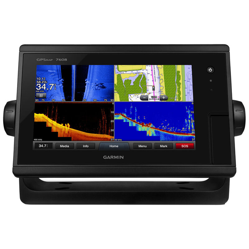
Designed for fisherman, cruisers, and sailors who demand high performance, ease of operation, and complete feature integration, the GPSMAP 7608 chartplotter with 8" multi-touch widescreen display has a 10 Hz internal GPS that updates position and heading 10 times per second. It is fully network capable, including the Garmin Network and NMEA 2000, and offers the conveniences of built-in Wi-Fi connectivity.
Features:
• High-performance, high-resolution 8" multi-touch widescreen display
• Preloaded BlueChart g2 charts for the coastal US and Bahamas and LakeVü HD maps covering over 17,000 lakes of which over 5,700 are HD lakes with 1' contours shore to shore
• Fully network capable for Garmin Marine Network and NMEA 2000 and supports NMEA 0183
• Supports radar, autopilot, instruments, multiple screens, FUSION-Link, sensors, black box sonar, digital switching, thermal cameras, GRID and more
• Support for premium GSD black box sonar and GCV scanning sonar module
• Advanced sailing and sail racing features
• Built-in Wi-Fi/ANT for use with Garmin Helm and BlueChart Mobile
• Bail Mount included
• FLIR thermal camera support
• IP Camera support
• Video input - 1 composite video
• Ethernet ports - 2
• Media integration- FUSION-Link
• 2 SD card slots makes it easy to add optional mapping
• Supports optional mapping including BlueChart g2 Vision charts with exclusive Garmin Auto Guidance
• Supports LakeVü HD and LakeVü HD Ultra with exclusive Garmin Auto Guidance
• Supports User Data Sharing
- Feature integration technology for boaters
- High performance and high resolution
- Internal GPS updates info 10 times per second
- Fully Garmin network capable
- Supports radar, autopilot, cameras, and more
Specs
Accepts Data Cards
Yes
Antenna
Internal/External
Dimensions
8.8"W x 5.6"H x 2.6"D
Display Resolution
1024 x 600
Display Size
8" diag.
Display Type
WSVGA
Included Cartography
BlueChart g2 / LakeVu
Model Number
GPSMAP 7608
Network/Interface
NMEA 2000
Waterproof
Yes
Unit Weight
6.50 lb
Brand
Garmin
MFG Part No.
55125
 800-700-1366